Property Record
170 E 9Th Ave, Runnemede, NJ 08078


Save to a Folder
{{folder.Name}}
{{folder.ListingIds.length}} Properties
{{folder.ListingIds.length}} Property
Create a New Folder
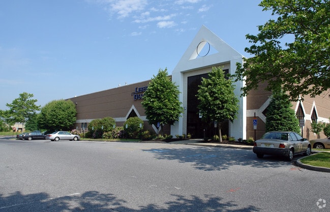
Property Detail
170 E 9Th Ave
30-00135-0000-00043-09
Camden
Industrialgeneral
New Jersey
B and X Area of moderate flood hazard, usually the area between the limits of the 100-year and 500-year floods.
43.9
0
1.75 AC
2026
Camden County
607200
Philadelphia
18,788 SF
Philadelphia-Camden-Wilmington, PA-NJ-DE-MD
NEARBY LISTINGS FOR SALE OR LEASE
DEMOGRAPHICS near 170 E 9Th Ave
1 mile
3 mile
5 mile
2025 Total Population
14,251
97,325
283,340
2030 Population
14,423
98,763
288,985
Pop Growth 2025-2030
+ 1.21%
+ 1.48%
+ 1.99%
Average Age
41
42
41
2025 Total Households
5,885
39,564
114,402
HH Growth 2025-2030
+ 1.16%
+ 1.51%
+ 2.00%
Median Household Inc
$89,057
$95,847
$87,803
Avg Household Size
2.40
2.40
2.40
2025 Avg HH Vehicles
2.00
2.00
2.00
Median Home Value
$251,844
$289,075
$293,047
Median Year Built
1959
1959
1961
Nearby Places
Map Layers
Map Styles
 Street
 Aerial
Layers
 Traffic
 Biking
Places
Listings with unknown addresses are not visible on the map
- Restaurants
- Banks
- Shops
- Fitness
- Groceries
PUBLIC TRANSPORTATION
COMMUTER RAIL
Lindenwold (Njt) (Atlantic City Line - NJ Transit Commuter Rail (NJ Transit))
Drive
Walk
Distance
Lindenwold (Njt) (Atlantic City Line - NJ Transit Commuter Rail (NJ Transit))
10 min
5.7 mi
Cherry Hill (Atlantic City Line - NJ Transit Commuter Rail (NJ Transit))
Drive
Walk
Distance
Cherry Hill (Atlantic City Line - NJ Transit Commuter Rail (NJ Transit))
13 min
6.9 mi
AIRPORT
Philadelphia International
Drive
Walk
Distance
Philadelphia International
27 min
14.6 mi
Freight Ports
Broadway Terminal - Pier 5
Drive
Walk
Distance
Broadway Terminal - Pier 5
11 min
6.1 mi
Nearby Properties
Address
Land Use
TOTAL SIZE
Lot Size
Zoning
Address
Land Use
TOTAL SIZE
Lot Size
Zoning
23.41 AC
BC2
Address
Land Use
TOTAL SIZE
Lot Size
Zoning
Address
Land Use
TOTAL SIZE
Lot Size
Zoning
30.63 AC
R10
Address
Land Use
TOTAL SIZE
Lot Size
Zoning
39,080 SF
18.60 AC
C2
Address
Land Use
TOTAL SIZE
Lot Size
Zoning
35 AC
R1
Address
Land Use
TOTAL SIZE
Lot Size
Zoning
40.92 AC
BC2
Address
Land Use
TOTAL SIZE
Lot Size
Zoning
Address
Land Use
TOTAL SIZE
Lot Size
Zoning
34.62 AC
Address
Land Use
TOTAL SIZE
Lot Size
Zoning
78.64 AC
Address
Land Use
TOTAL SIZE
Lot Size
Zoning
25.77 AC
R10
Address
Land Use
TOTAL SIZE
Lot Size
Zoning
Address
Land Use
TOTAL SIZE
Lot Size
Zoning
27.25 AC
Address
Land Use
TOTAL SIZE
Lot Size
Zoning
Address
Land Use
TOTAL SIZE
Lot Size
Zoning
Address
Land Use
TOTAL SIZE
Lot Size
Zoning
67.33 AC
BC2
Address
Land Use
TOTAL SIZE
Lot Size
Zoning
8.18 AC
Address
Land Use
TOTAL SIZE
Lot Size
Zoning
41.09 AC
Address
Land Use
TOTAL SIZE
Lot Size
Zoning
Address
Land Use
TOTAL SIZE
Lot Size
Zoning
Address
Land Use
TOTAL SIZE
Lot Size
Zoning
Address
Land Use
TOTAL SIZE
Lot Size
Zoning
3.50 AC
Address
Land Use
TOTAL SIZE
Lot Size
Zoning
15.96 AC
BC2
Address
Land Use
TOTAL SIZE
Lot Size
Zoning
2,560 SF
167.08 AC
ROC
Address
Land Use
TOTAL SIZE
Lot Size
Zoning
16.84 AC
Address
Land Use
TOTAL SIZE
Lot Size
Zoning
17.27 AC
Address
Land Use
TOTAL SIZE
Lot Size
Zoning
14.49 AC
BC2
Address
Land Use
TOTAL SIZE
Lot Size
Zoning
Address
Land Use
TOTAL SIZE
Lot Size
Zoning
31.57 AC
RM2
Address
Land Use
TOTAL SIZE
Lot Size
Zoning
17.40 AC
Address
Land Use
TOTAL SIZE
Lot Size
Zoning
8.58 AC
BC2
The World's #1 Commercial Real Estate Marketplace
Connect with us
© 2026 CoStar Group
The information above has been obtained from sources believed reliable. While we do not doubt its accuracy we have not verified it and make no guarantee, warranty or representation about it. It is your responsibility to independently confirm its accuracy and completeness. Any projections, opinions, assumptions, or estimates used are for example only and do not represent the current or future performance of the property. The value of this transaction to you depends on tax and other factors which should be evaluated by your tax, financial, and legal advisors. You and your advisors should conduct a careful, independent investigation of the property to determine to your satisfaction the suitability of the property for your needs.